Gran Trail Courmayeur - 100Km - 7900mD+ | S01E01
TORX® offers 100 PAX (TOR330 bibs) for the finishers of the GTC100, regardless of ranking.
Register for the GTC100 2023, become a finisher and in 2024 you will be
able to register for the TOR330 - Tor des Géants® without going through
the draw.
The danger of civilization, of course, is that you will piss away your life on nonsense.
-Jim Harrison
E pronto! Após um ano inteiro sem objetivos, na sequência do enorme cansaço que senti após os dois desafios de 2021, finalmente tenho uma meta no horizonte.
Comecei 2021 com uma carga de treinos brutal, em parte para compensar a falta de treino durante a pandemia do Covid-19, em parte para participar nos desafios do meu clube RUN 4 FUN, e porque tinha a participação nos 350 km do TOR des Géants no horizonte (Setembro 2021).
No entanto isso provou ser uma péssima estrategia. Aliado ao facto de as primeiras provas de 2021 terem sido os 50 km do Ultra Trail do Alvarinho, seguido 10 dias depois pelos 165 km do TPG, deixou-me num estado debilitado e depauperado de consumado "Overtraining".
Trans Peneda Gerês - Uma vitória que custou mais do que qualquer derrota
Neste gráfico pode-se ver que os meses de Fevereiro, Março e Abril foram de completa loucura, com meses com 700 km de treino total, seguidos por uma brutal quebra.
Dessa quebra só comecei a recuperar em Agosto deste ano, e mesmo assim muito aquém dos meus volumes habituais de treino, que rondam os 400 km por mês e não apenas cerca de 270 km, como tenho feito. Em Janeiro terei que aumentar a carga para me ir aproximando do nível adequado.
O último mês em que completei mais de 400 km foi em Abril de 202, portanto já quase passaram 2 anos desde então.
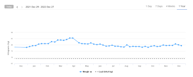
Outra coisa fundamental que terei que fazer será baixar dos 80 kg para cerca de 70 kg. Acho que nem vale a pena explicar porquê. Mas basta pensarem que qualquer kg a mais num deslocamento de 1.000 metros equivale em termos energéticos a deslocar uma tonelada num metro.
Os meus treinos estão a precisar de um pouco mais de regularidade. Não basta enfiar uns treinos bem longos uma vez por semana. É necessário também treinar quase todos os dias:
Mas estou certo que quando alinhar na linha de partida estarei pronto para cumprir este desafio.
Courmayeur is located at the foot of Mont Blanc, and has the honor of being Italy’s highest town. The Valle d’Aosta Trailers, organizes three races that traverse the legendary landscape just outside of town. The 30km route travels mainly along Val Ferret, and showcases a panoramic view of Courmayeur from La Suche. The 55km route explores Val Veny, featuring a new route, dell’Orrido, out of Pre Saint Didier, with a panoramic balcony, a new crossing between Colle di Youlaz and Col Chavanne, and a descent through Calcaires Pyramides. And if you don’t want to miss anything, you’ll like the 100km route which combines the best of both.
https://runthealps.com/races/gran-trail-courmayeur/
https://www.gtcourmayeur.com/en
MANDATORY EQUIPMENT
Equipment that all runners must carry with them for the entire race
- A cup or other container suitable for drinking at refreshment points
- Mobile phone to be kept on at all times, with ringtone on to receive communications from the Race Direction (enter the organisation's security number +39 3456729373, do not mask the number and do not forget to start with a charged battery)
- Identity document and health insurance card (or similar)
- Two survival blankets
- Food supplies
- Water supply (at least 1.5L)
- Two working headlamps and spare batteries (mandatory only for GTC100 and GTC55)
EQUIPMENT SUGGESTED TO COMPLETE THE TEST SAFELY
Equipment that runners may carry in their backpacks, according to their own assessment or as instructed by the race organizers
- Shoes of a category between A2 and A5 (intermediate-> trail)
- Anti-slip device (crampons) (eg: NORTEC , GRIVEL , CAMP)
- Hooded thermal jacket suitable for cold temperatures (down to -15°)
- Hooded jacket with rainproof shell, breathable waterproof lining and thermo-taped seams
- Running bottoms or leggings (to cover the knee at least);
- Long waterproof over-trousers
- Warm top layer: long-sleeved top in technical fabric, long trousers
- Hat that covers the ears
- Warm, waterproof gloves
- Change of clothes
- Whistle
- Self-treatment first aid kit
- Power bank to recharge phone and other equipment
- Altimeter
- GPS navigator uploaded with the race route (downloadable in KML or GPX format from www.gtcourmayeur.com)
- Pocket knife
- Kit for little reparations
GTC2022 is part of the TORX® eXperience
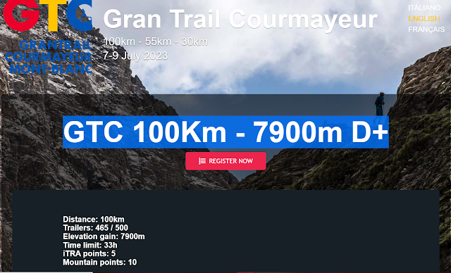
Distance: 100km
Trailers: 465 / 500
Elevation gain: 7900m
Time limit: 33h
iTRA points: 5
Mountain points: 10
Qualifying race for Tor des Géants® 2023: 100 bibs will be available in 2023 for the finishers of GTC100 2022, who may bypass the draw and register directly for the Tor des Géants® 2023.
ROUTE
The route winds along paths in the area between Courmayeur, Pré-Saint-Didier and La Thuile for a total of 100km, mainly through Val Veny and Val Ferret, with a positive elevation gain of 7900 metres.
Starting out from the Piazza Abbé Henry in Courmayeur (1250m ASL), it heads towards Dolonne and the Fonti Vittoria then takes the trail leading to Champex di Pré-Saint-Didier.
ATTENTION! Changes to the GTC100 route
The path from Pré-Saint-Didier to Petosan has been closed due to safety reasons. In agreement with the Morgex local authority and the Arpy Hostel, the management of the race has decided to change the route as follows: from Pré-Saint-Didier to the caves, then passing through the Arpy village (the refreshment point will be at the Hostel), climbing up until the Colle della Croce and then descending to La Thuile.
You join then the trail that leads to the Deffeyes Refuge (refreshment point, 2500m ASL) after a short section equipped with chains.
From the refuge, the trail descends to the waterfalls and arrives at Arly in La Thuile (1450m ASL), which marks completion of approximately one third of the overall route.
Following a part of the route from the Tor des Géants® in reverse, the trail then passes the entrance to the Youlaz valley (refreshment point, 2047m ASL), Colle dell'Arp (2572m ASL), Colle di Youlaz (2661m ASL) and the highest point of the race below Mont Nix (2830m ASL).
A long section then takes the trail runners up to Colle du Berrio Blanc (2818m ASL) and Mont Fortin (2755m ASL), where there's another refreshment point in a portable hut flown in by helicopter.
From here it runs alongside the lakes towards Col Chavanne (2598m ASL), then descends to Col de la Seigne (2510m ASL) and the "Casermette" (2290m ASL). The trail then goes around the Pyramides Calcaires (2573m ASL) and there's another refreshment point at the Elisabetta refuge (2197m ASL).
From here the trail follows the Tour du Mont Blanc, passing by Lake Combal (1952m ASL), Arp Vieille (2303m ASL) and Lake Checrouit (2151m ASL), and arriving at the Maison Vieille refuge (1952m ASL), which is the last refreshment point before the life base in Courmayeur.
Road goes down towards the Val Veny, and from here starts the climb towards the Pavillon du Mont Fréty that leads to the intermediate Skyway Monte Bianco station where the life base is located.
Using the old path, you reach La Palud and, after crossing the bridge, take the path to rejoin the balcony at Lechey.
The magnificent Val Ferret balcony takes runners up to the Bonatti refuge and the Malatrà valley, which marks the approximate half-way point of the race, and where a refreshment area is set up on the Giouè pastureland (2215m ASL).
The ascent of the last two hills, Entre deux Sauts (2524m ASL) and Col Sapin (2435m ASL), starts from here, followed by a descent through Curru, La Suche and L'Ermitage, returning to the finish point at Jardin de l'Ange in Courmayeur.
NOTES
The maximum time allowed for the race is 33 hours.
The trail is highly technical with considerable differences in altitude, exposed sections and the possibility of snowfields, but is run entirely along classified hiking paths.
Sections on paved roads are kept to a minimum and only on public roads where the route passes through built-up areas.
PARTICULAR POINTS OF INTEREST
-
The long section between Colle di Youlaz and Col Chavanne
-
The descent from Col de la Seigne to the Elisabetta refuge and Lake Combal, passing by Colle delle Pyramides Calcaires
- Skyway Monte Bianco - Pavillon du Mont Fréty
-
The Val Ferret balcony between the Bertone refuge and the Bonatti refuge
-
The panoramic view of Courmayeur from La Suche
REFRESHMENT POINTS
There are several rescue points and refreshment points along the route. Before leaving a refreshment point, runners must ensure they have enough food and water to last them until the next one. The final refreshment point in Courmayeur will supply hot meals.
GPX-KML-MAPS and TIME BARRIER


.PNG)


Comentários
Enviar um comentário